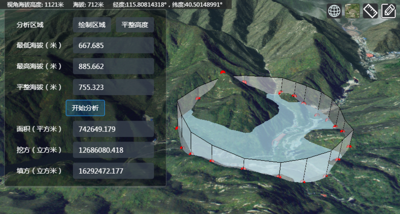
最近做一个填挖方分析的三维功能模块,受前人启发实现了一种取最高最低高程,以及填挖方分析的方法。
前人的启示
Cesium- How to calculate highest point, lowest point, average altitude in a specified area around the click position?
翻译如下:
Cesium - 在选定区域如何计算最高点、最低点、平均高程?
Qandeel Abbasi: 我的解决方案是在一个方形区域,通过双线性插值,取得范围内采样点的经纬度,然后使用 Cesium 提供的 sample terrain 接口,来获取所有采样点的高程,然后取得最高、最低,并计算平均值……
最高、最低高程
Qandeel Abbasi 的思路,其实就是通过采样获取最高、最低高程,采样点越密集、越多,精准度就越高。
但他在原答案中贴出的代码,是谷歌地图的 API……
通过查阅,我采用了更方便、通用的方式——turf。
1
2
3
4
5
6
7
8
9
10
11
12
13
14
15
16
17
18
19
20
21
22
23
24
25
26
27
28
29
30
31
32
33
|
const turfPolygon = turf.polygon([[
[115.81892851491955, 40.4802518813306],
[115.81630221287354, 40.482671616134674],
[115.81951377727235,40.4833706498091],
[115.81892851491955, 40.4802518813306],
]]);
const turfExtent = turf.bbox(turfPolygon);
const turfSamplePoints=turf.pointGrid(turfExtent,0.003,{
units:'kilometers',
mask: turfPolygon,
});
const cesiumSamplePoints = [];
for (let i = 0; i < turfSamplePoints.features.length; i++) {
const coord = turfSamplePoints.features[i].geometry.coordinates;
cesiumSamplePoints.push(Cesium.Cartographic.fromDegrees(coord[0],coord[1]));
}
Cesium.when(Cesium.sampleTerrain(viewer.terrainProvider,11,cesiumSamplePoints),(updatedPoints) => {
let highest = 0;
let lowest = 8888;
updatedPoints.forEach(point=>{
if (point.height>highest) {
highest = point.height.toFixed(3);
}
if (point.height<lowest) {
lowest = point.height.toFixed(3);
}
});
|
填挖方分析
填挖方分析,采用了微积分的思想。
获取最高最低高程的过程中,已经在 polygon 内进行了采样。
可以利用这些采样点,将 polygon 平均划分成 n 个小区域。
每个小区域的面积乘以高程差,即为该小区域的挖方或填方体积,累加即可得总 的填挖方体积
1
2
3
4
5
6
7
8
9
10
11
12
13
14
15
|
const level = 620;
const area = turf.area(turfPolygon).toFixed(3);
const diffArea = area / cesiumSamplePoints.length;
let cut = 0;
let fill = 0;
cesiumSamplePoints.forEach((point) => {
if (point.height > level) {
cut += (point.height - level) * diffArea;
} else if (point.height < level) {
fill += (level - point.height) * diffArea;
}
});
|
参考
示例:
cut&fill